How to draw India Map To draw a map of India, start by outlining the basic shape of the country, which resembles a slightly elongated hexagon with a peninsula extending into the Indian Ocean. Next, draw the borders of India’s neighboring countries, including Pakistan to the northwest, China and Nepal to the north, Bhutan to the northeast, and Bangladesh and Myanmar to the east. Then, sketch the coastline along the Arabian Sea to the west and the Bay of Bengal to the east, including prominent features such as the Gulf of Kutch, the Gulf of Khambhat, and the Andaman and Nicobar Islands. Finally, add major geographical landmarks such as the Himalayan mountain range in the north, the Thar Desert in the northwest, and the Deccan Plateau in the south. Ensure accuracy in proportions and placement of key geographical features to create a recognizable and informative map of India.
How to draw India Map
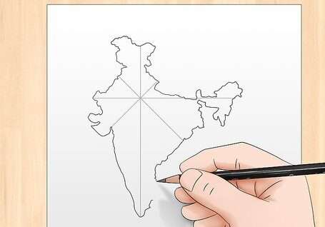
- Outline India’s Basic Shape: Begin by sketching the outline of India, which resembles a slightly elongated hexagon with a peninsula extending into the Indian Ocean.
- Draw Neighboring Countries’ Borders: Add borders for neighboring countries, including Pakistan to the northwest, China and Nepal to the north, Bhutan to the northeast, and Bangladesh and Myanmar to the east.
- Sketch Coastline Features: Draw the coastline along the Arabian Sea to the west and the Bay of Bengal to the east, including significant features such as the Gulf of Kutch, the Gulf of Khambhat, and the Andaman and Nicobar Islands.
- Include Major Geographical Landmarks: Add major geographical landmarks such as the Himalayan mountain range in the north, the Thar Desert in the northwest, and the Deccan Plateau in the south.
- Label States and Union Territories: Optionally, label India’s states and union territories, ensuring accurate placement and proportions.
- Add Details: Fill in additional details such as rivers, lakes, and cities to enhance the map’s accuracy and informational value.
- Check Accuracy: Review the map to ensure accurate proportions, placement of features, and adherence to geographical boundaries.
- Refine and Finalize: Make any necessary adjustments or refinements to improve the map’s clarity and accuracy, then finalize the drawing
List of materials required for drawing the map
Here’s a list of materials required for drawing a map of India:
- Map Outline: A printed or hand-drawn outline of India’s shape to use as a reference.
- Drawing Paper: High-quality drawing paper or sketch paper to draw the map on.
- Pencil: A sharpened pencil for sketching the outline and adding details.
- Eraser: A soft eraser to correct mistakes and remove unwanted lines.
- Ruler: A straight ruler to draw straight lines for borders, coastlines, and other features.
- Colored Pencils or Markers: Colored pencils or markers to add color to the map, distinguishing between landmass, water bodies, and other features.
- Fine-Tip Pens: Fine-tip pens for outlining and labeling states, union territories, rivers, and other geographical features.
- Compass: A compass to draw accurate circles or arcs for features like the Andaman and Nicobar Islands.
- Reference Map: A reference map of India for accuracy in drawing borders, coastlines, and geographical features.
- Optional: Map Projection Device: A map projection device or software for accurately projecting the shape of India onto the drawing paper.
Suggestions for achieving precision and correctness
Here are some suggestions for achieving precision and correctness when drawing a map of India:
- Use a Reference: Start with a reference map of India to ensure accuracy in drawing the outline, borders, and geographical features.
- Measurements: Use a ruler and compass to make precise measurements and draw straight lines for borders and coastlines.
- Scale: Consider the scale of your map to ensure that proportions are accurate. Decide on a scale beforehand and stick to it throughout the drawing process.
- Double-Check: Double-check your work as you go along to catch any mistakes or inaccuracies early on. Compare your drawing to the reference map frequently.
- Take Your Time: Drawing a map requires patience and attention to detail. Take your time to ensure each feature is drawn accurately and precisely.
- Use Guidelines: Sketch light guidelines or gridlines on your drawing paper to help maintain proportions and alignment.
- Labeling: Use clear, legible handwriting when labeling states, union territories, rivers, and other geographical features. Ensure labels are placed accurately.
- Erase Mistakes Carefully: If you make a mistake, use a soft eraser to carefully remove unwanted lines without damaging the paper.
- Practice: Practice drawing maps on a regular basis to improve your skills and develop a steady hand for precision.
- Seek Feedback: Once you’ve completed your map, ask for feedback from others to identify any areas that need improvement or correction.
Conclusion
In conclusion, achieving precision and correctness when drawing a map of India requires careful attention to detail, accurate measurements, and frequent reference to How to draw India Map a reliable source. By using appropriate tools, taking your time, and double-checking your work, you can create a map that accurately represents the geographical features and boundaries of India. Practice and patience are key, as is seeking feedback to identify and correct any errors or inaccuracies. With dedication and effort, you can produce a map that is not only visually appealing but also informative and accurate for educational or reference purposes.
FAQs
Q: 1 What are the basic steps to draw a map of India?
Ans::Start by outlining the shape of India, then add neighboring countries’ borders, sketch coastline features, include major geographical landmarks, and label states and union territories for clarity.
Q: 2 Do I need any specific materials to draw a map of India?
Ans:Yes, you’ll need materials like drawing paper, pencils, erasers, rulers, colored pencils or markers for adding details, and a reference map of India for accuracy.
Q:3.How can I ensure precision and correctness when drawing the map?
Ans; Use a reference map, take measurements accurately, double-check your work, use guidelines for alignment, label features clearly, and erase mistakes carefully.
Q: 4.What are some common mistakes to avoid when drawing a map of India?
Ans: Common mistakes include inaccurate proportions, misaligned features, incorrect labeling, using the wrong scale, and not referring to a reliable source map.